
Finding Grand Junction Residents by Street
A street-by-street search should separate location, ownership, recorded parties, registration, and historic presence. Begin with the street index, because a road name can have a current form and an older alias. Run the normalized address through the Mesa Assessor, write down the parcel and account, and then inspect the same location in GIS. Only after that should a voter report, deed index, or historic directory be treated as a match.
The address trail is easiest to audit when every step keeps the date and source system:
- Normalize the road name, prefix, suffix, house number, city, county, and postal label.
- Use the assessor address, parcel, or account route and save the location, mailing, owner, neighborhood, and prior-parcel fields.
- Open the Mesa GIS viewer or District Lookup to test jurisdiction, zoning, precinct, service, and nearby-parcel context.
- Search the Landmark recorder by party, legal description, reception number, or date, then inspect the document type.
- Use a defined voter report or historic directory when the question needs a dated presence clue, not a guess about every household.
That sequence makes the Grand Junction street directory a chain of public record leads rather than an invented list of occupants.
Grand Junction Assessor Address Fields
The Mesa County Assessor Property Lookup is the main address-keyed entry point. Its tabs include Address, Parcel Number, Account Number, Owner Name, Neighborhood, Intersection, Place Name, and Lat Lon. The address form takes two street inputs and can narrow by area or township and neighborhood. A blank field acts as a wildcard. The standards page says not to use an asterisk, commas, periods, or dashes, and it warns against casual forms such as a full “Drive” when the accepted abbreviation is DR.
When a full address returns nothing, try the house number alone, then the parcel number, account number, intersection, place name, or approximate coordinates. A parcel report may show the location address, associated addresses, mailing address, owner or joint owner, neighborhood, legal description, TAC, approximate latitude and longitude, and linked previous or associated parcels. The report date belongs in the research note. Mailing and situs are separate fields, and neither one alone proves present occupancy.
| Assessor tab | Fields observed | Street-use purpose |
|---|---|---|
| Address | Two street entries, area or township, neighborhood | Find a location when the road form is known |
| Parcel Number | 15-digit dashed parcel, township, range, section, quarter, block, lot | Rejoin a split or older parcel trail |
| Account Number | Account value such as R023126 | Open the parcel report and print view |
| Intersection or place | Two-road context or named place | Find a broad street segment before narrowing |
| Owner or neighborhood | Owner-name route and neighborhood selector | Browse context, with display limits preserved |
The Mesa address standards image is a practical check before a street search. It helps bridge a historic road label and the current form without erasing the original spelling.
Open the Mesa address standards before checking the capture below; street lookup success can turn on a suffix, prefix, or punctuation rule.
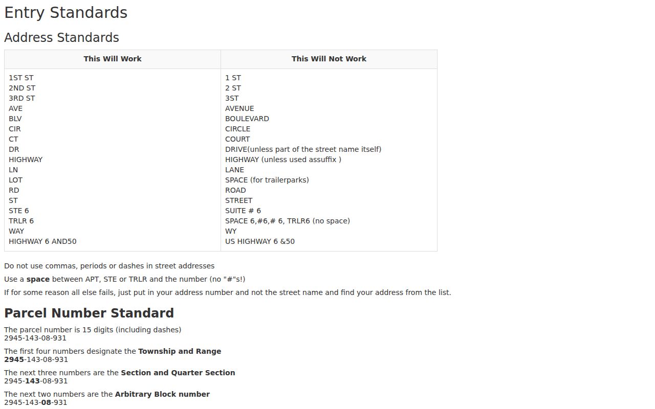
The standards capture belongs beside the search-field table because the accepted road form can decide whether a parcel appears.
Grand Junction Street Grid and Aliases
Grand Junction's street system carries a strong grid logic. Main divides north and south, and First divides east and west in the original townsite. Numbered roads generally run north to south, while lettered roads run east to west. The city street index identifies quarter, half, and three-quarter road forms, and the historic guide says even numbers generally fall on the north or east side while odd numbers fall on the south or west side.
Aliases matter when a directory, deed, city survey, or newspaper uses an older label. Unaweep Avenue is C Road. North Avenue is Highway 6 Bypass. Patterson Road is F Road. Broadway is State Highway 340. 32 Road is State Highway 141. The I-70 Business Loop also appears as Highway 6 or Highway 6 and 50 west of First. Keep a two-column alias ledger, then test both forms in the assessor, GIS, directory, and recorder routes.
Recent change matters too. Mesa Planning recorded a November 14, 2024 decision renaming C Road to Unaweep Avenue from Highway 50 east to 29 Road. A historical hit under C Road is not a mismatch merely because a current map uses Unaweep Avenue.
Open the Mesa County GIS viewer before viewing the map capture below; it adds context that a text address field cannot supply.
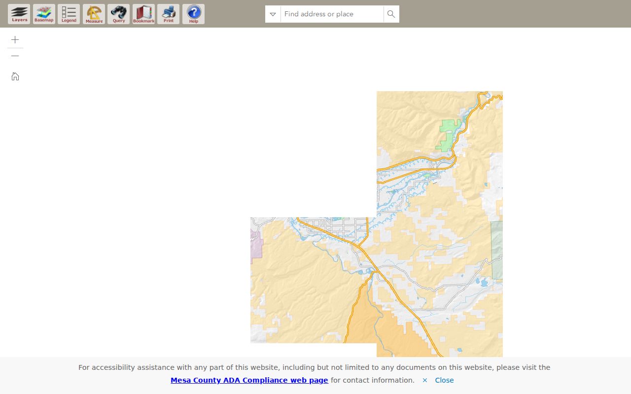
The map should support, not replace, the assessor and legal description.
Note: Orchard Mesa addresses can be irregular across years because annexation began in 1966 and older directory forms may not match today's grid.
Grand Junction GIS Parcel Walk
After the assessor returns a parcel or account, use the current Mesa GIS viewer to check the surrounding map. Search accepts address, parcel, account, subdivision, intersection, place, or latitude and longitude. Query with Attributes can isolate a layer, while results open in a second tab and the layer list is nested. District Lookup adds municipality, jurisdiction, Persigo, zoning, future land use, political districts, school districts, service providers, floodplain, wildfire, airport, and mineral or geologic context.
A street directory built from a map must distinguish a point from a boundary. The public ArcGIS parcel-point service exposes fields such as ACCOUNTNO, PARCELNUM, ASSOCPAR, and LOCATION and has a maximum record count of 2,000. A nearby pin does not by itself establish an adjacent parcel. Record each surrounding account, open its assessor report, and compare the legal description or recorded plat before using the word adjacent.
- Parcel
- A county land unit with an account or parcel identifier. It is not automatically the same as a house or household.
- Situs address
- The physical location tied to a parcel. Keep it separate from a tax or mailing address.
- Plat
- A recorded map that can show lots, blocks, streets, and subdivision relationships.
- Criss-cross directory
- A reverse-style directory organized by address or telephone rather than only by surname. A complete official Grand Junction run was not located in the reviewed sources.
The county calls GIS a reference and planning resource. A map layer can guide the next record request, but it is not a boundary survey or chain-of-title proof.
Grand Junction Records by Address
Several record sets can be keyed to a street, but each one shows a different relationship. The following coverage map keeps the roles apart and identifies the fallback when no open index is available.
| Record set | Keeper | Address result | Access |
|---|---|---|---|
| Assessor parcel | Mesa County Assessor | Location, mailing, displayed owner, use, neighborhood, legal fields | Public lookup and report |
| GIS parcel and district | Mesa County GIS | Parcel points, nearby polygons, jurisdiction, zoning, services | Viewer and ArcGIS service |
| Deed and lien index | Mesa Clerk and Recorder | Filed parties, instrument type, reception and legal clues | Free view; copies and certification cost |
| Building permits | Mesa Community Development | Address, permit, application, inspection, or occupancy record by era | Current login route; pre-1988 public search |
| City WebDrawer | Grand Junction City Clerk | Addressed permits, licenses, ordinances, and supporting metadata | Custom search; not every city record |
| Voter report | Mesa Elections | Selected residential address, precinct, party, status, or history fields | Form, fee, filter, and confidentiality rules |
| Directory or newspaper | Library and licensed collections | Dated people, business, office, and public-notice clues | Microfilm, image, or database access |
The parcel or account is often the best bridge between systems, but a city WebDrawer address may carry an old permit while a directory carries a former occupant. Save the record date, query form, and source-specific identifier before comparing.
Permits and Code Cases by Address
Mesa County building records split at 1988. The current route asks for an address, then a populated address choice, before opening permits in the Maintstar portal. The instruction page says an account or login is required to view current records. The pre-1988 OnBase route is more exposed: enter at least one value, add an optional date or range, use the asterisk wildcard where the county instructs it, choose Search, and open the document link.
The county describes 56,524 pre-1988 documents, including applications, permits, and Certificates of Occupancy. It also notes that sequence 16-02452 through 16-03409 was skipped because of a computer issue. A missing sequence is therefore not proof that an address had no permit. If the current portal blocks the document, contact Community Development or request an existing record set through Mesa CORA.
Grand Junction city records take a parallel route. City Clerk WebDrawer supports frequently viewed, custom, easy, and grouped searches. Custom criteria use field, operator, value, and And or Or rows, with exact-string and up to three sort choices. A sample record titled “Permit - Fence - 1992 - Mr. Mendicelli - 803 Pitkin and 815 Pitkin” shows how two address numbers can sit in one historic record.
The Mesa Assessor Sales Lookup adds a different address comparison route. Its filters include sale date, qualification, year built, sale amount, acreage, heated square feet, beds, baths, neighborhood, subdivision, architectural type, and detailed use. A nearby result is a comparison record, not a current owner or resident.
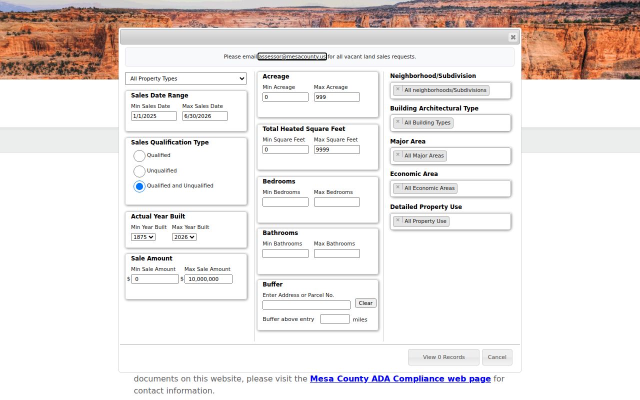
The sales-search capture shows why qualification code, date range, address or parcel buffer, and search date belong in the street record ledger.
Open the pre-1988 permit search before viewing the capture below; it is the public fallback for older address research.
The capture does not supply the current condition of a building.
For code enforcement, the city lists animals, fences, debris, weeds, storage, vehicles, snow, trailers, and yard sales. No public address index was verified, so use a focused City CORA request with the address, date range, and violation type.
Deed Trails Along Grand Junction Streets
A street-level deed search works from a parcel or a party, not from a broad city name. Use Landmark's party search with document category, document type, town, and date range. If a reception number, book and page, or legal description is known, switch to that tab. Record the reception number, recorded date, grantor, grantee, document type, legal description, book or page, image pages, and marginal references.
Recorded images and indexes are described as 1883 to present, with a pre-1969 image route by reception number. The index can contain omissions or inaccuracies, and the office record controls. A quitclaim, deed of trust, lien, release, easement, plat, or affidavit may explain a parcel event without transferring fee title. Organizations, trusts, estates, spouses, former names, and misspellings all call for variant searches.
Open the Mesa Landmark recorder search before viewing the capture below; it shows the name and document routes.
Use the official office for an image or certified copy when an index row matters.
Note: A deed party, assessor owner, tax mailing addressee, directory occupant, and voter can all be different people with different dates.
Voter and District Clues by Street
Mesa Elections can provide defined reports filtered by county, district, precinct, party, status, and phone inclusion. The form lists report codes for registered lists and voter history, plus maps and secure-email Excel delivery. It does not present a ZIP-wide street directory selector in the observed fields. Ordinary lists omit confidential voters, and special-district certified lists follow a different process.
District Lookup can add commissioner, voting precinct, school district, municipality, and service-provider context to a parcel. A precinct is not the same as a legislative district, congressional district, commissioner district, or school district. Keep the election year and report or map type with the street record, because boundaries can change.
For an individual, the Colorado voter self-lookup uses first name, last name, ZIP, and birthday. It can fail for a confidential voter or an under-18 record. A missing name is not a reason to expose a protected address or to turn the street search into a household claim.
Grand Junction Road Renames
Address history becomes harder around renamed roads and annexed areas. Use the January 2026 city street index for the current city-limits spelling, then preserve the old grid name in the historic field. The C Road and Unaweep Avenue change is the clearest recent example. North Avenue, Patterson Road, Broadway, and 32 Road also have alias pairs that appear in official guidance.
Orchard Mesa adds a geography check. City survey material says annexation began in 1966, and directories there can use irregular address forms. A modern postal ZIP cannot back-project a historic address by itself. Compare street index, directory image, Sanborn sheet, city survey, parcel history, and legal description. If a road search fails, change one field at a time and record the failed form instead of silently rewriting it.
The street grid also has local anchors. North Seventh is described in city-history material as the heart of the original square mile, with Grand, Gunnison, and Main forming the broader plan. Those clues can help locate a historic sheet when a source names a block but not a modern parcel.
Limits of a Grand Junction Street Directory
A street directory cannot show every person connected to a location. Public records do not create a general list of household members, utility customers, private customers, restricted DMV addresses, or protected voter addresses. An assessor mailing address can be a PO Box. A directory can show an old occupant. A map polygon can describe an association area without naming a member.
The Colorado Privacy Act, CORA and CCJRA do not turn every source into one open database. Vital records require identity and eligibility. Court files can be juvenile, sealed, suppressed, protected, or redacted. The Address Confidentiality Program and voter confidentiality rules can hide a lawful address. Use the record type that answers the question and stop at the custodian's stated boundary.
Lawful personal use. Street and address records in Grand Junction are research leads, not tools for stalking, harassment, intimidation, or harm. Never try to defeat a sealed, confidential, protected, or restricted record.
When the goal changes from a whole street to one person, record the name variants, date, relationship to the address, and confidence level before moving to the resident lookup route.